
The following essay is taken from  with permission from the author.
The Journey of the Sargassum
There is a sea on the Planet Earth which has no shores. It is over two million square miles in size, and it is completely distinct from its surrounding waters both oceanographically and ecologically. It supports roughly a million tons of plant life, which provides habitat for over 100 species of fish and 140 species of invertebrates, and many of them occur nowhere else. All this teeming abundance is in waters that are so nutrient poor that visibility can be a couple hundred feet on a good day. If not for this astonishing ecosystem, in this astonishing sea without shores, this place would be an aquatic desert.
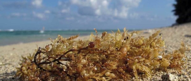
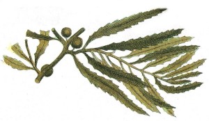
It’s called the Sargasso Sea. It is contained by a clockwise gyre of four different ocean currents that circle between North America, Europe and North Africa, and it is about 1,000 miles across at its widest point. Its sea level is three feet higher than the surrounding waters, and the waters are warmer and saltier. The foundation of the ecosystem is a remarkable seaweed called sargassum (Sargassum natans and Sargassum fluitans), a highly unusual marine algae that is completely pelagic (free drifting). It reproduces asexually through simple fragmentation, and it can do so easily, and anywhere it goes. Because it is pelagic, it does not have to compete for precious real estate on the ocean bottom, and it also is not limited to shallow coastal waters like the benthic (attached) seaweeds, which not only have to find some substrate to attach to, but then have to be able to grow up into some light so they can photosynthesize. Sargassum has none of those constraints, and it grows in great mats and windrows in a sprawling, mid-ocean world where the coastlines are hundreds of miles away and the bottom is sixteen thousand feet down. It consumes carbon and produces oxygen in huge quantities. It has been called the golden floating rainforest of the ocean.
Sail east from anywhere in the US or west from anywhere in Europe and you’ll probably have to cross it. Sailors have known about it for centuries, and it has broken some strong hearts when the seaweed was sighted from shipboard by early explorers, and they thought they were approaching land.
For myself, I started reading up on it because, though we’ve always gotten a little sargassum on our beaches around here, recently it’s been hitting us in huge quantities. It’s ugly. It’s slimy. It puts out hydrogen sulfide gas as it decomposes and it stinks. The tourists are not pleased. “WTF?” my friends are all asking me—but in that quaint way we older folks have of spelling things out completely.
* * * *
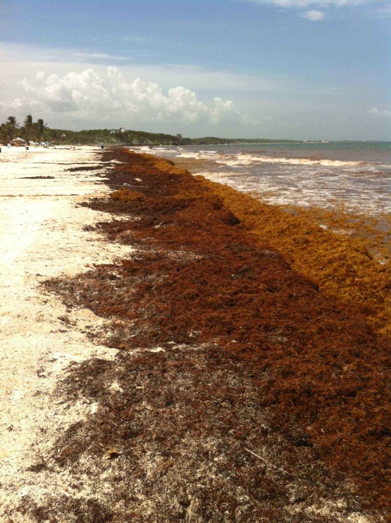
Sargassum on the Tulum Beach
Well, I knew this would be a tough one and I was right. We’ve all read several articles in the popular press about this and none of them answer the question why, so I knew it wouldn’t be easy to find. A week into it I muttered to myself that it might have been easier if I’d been looking up the meaning of life. Then, on a whim, I did so. It’s 42. If you’ve read any Douglas Adams you already knew that. But anyway, bear with me, because I did arrive at what I consider to be an answer, and getting there was a pretty good trip, not just through the life cycle of one of the most interesting seaweeds in the world, but also the amazing Sargasso Sea, the world’s ocean currents, climate change, and agricultural and urban runoff as measured in continent-fulls.
It used to be thought that the Sargasso Sea was a one-way destination for sargassum seaweed. The model went like this: The sargassum grows in the north-west Gulf of Mexico (they’ve always gotten some on the Texas beaches), and that was thought to be sort of its nursery. Then the Gulf Stream current catches it and whips it around the southern tip of Florida and up the east coast of North America, and it settles out into the gyre that is the Sargasso Sea, and there the story ends.
The problem with that model is that it’s a one-way model—the sargassum goes in, and nothing comes out—and ecologists just hate one-way models. To any ecologist with a proper reverence for the Interconnectedness of Everything (capital ‘I’, capital ‘E’), if you’re looking at a one-way system, you’ve only found half the system. It wasn’t until last year that three Texas A&M scientists found what appears to me to be the other half. They developed a way to identify sargassum in satellite photos. If there is enough of it, it reflects wavelengths of light that jump right out at you if you use the right filter. Even if there is not enough to be directly visible, its presence breaks surface tension and dampens wave motion, creating what the scientists call a “slick” on the water. They started going through images, all the way back to the year 2000, which was the earliest year that the photos had enough resolution for this. What they found was that every year, a weather occurrence called the Azores High Pressure System creates strong south-bound winds, and they don’t exactly disrupt this huge North Atlantic Gyre—but they jail-break a bunch of sargassum out of it.
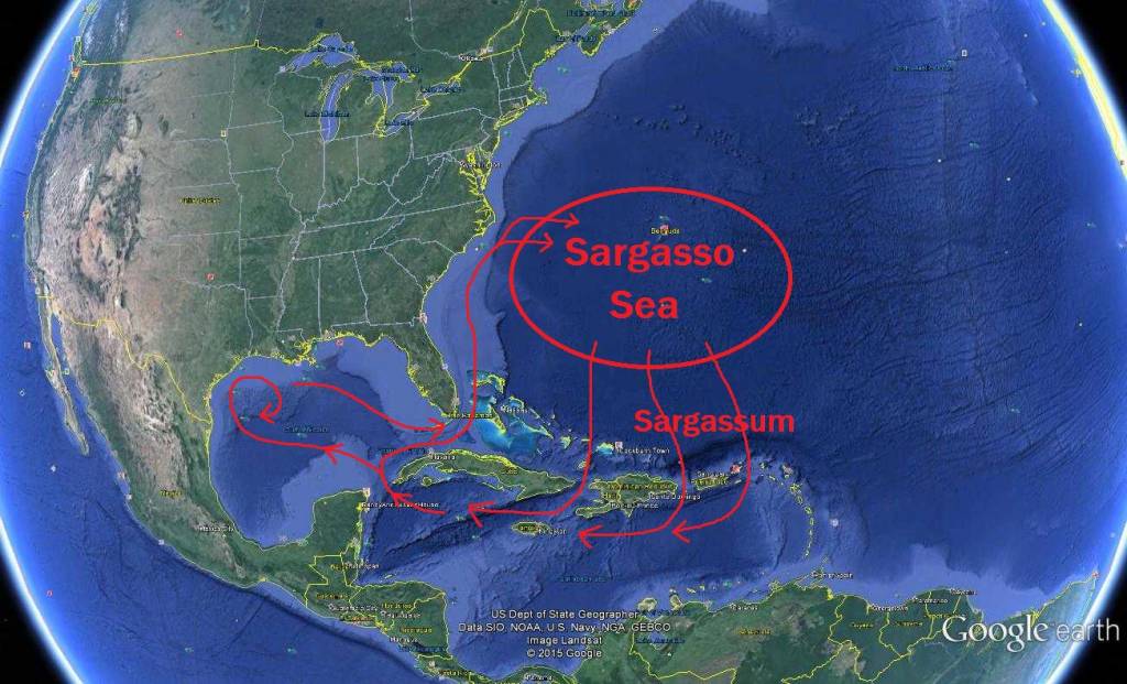
The Sargassum Loop System
This expanded hugely the travels that we understood Sargassum to make. When it breaks out of the gyre, it drops down through three different passages between the island nations that border the Caribbean on the north—between Cuba and Haiti, between Dominican Republic and Puerto Rico, and between Saint Thomas and Anguilla the sargassum is blown through the passages, and it ends up in the Caribbean, where the North Equatorial Current grabs it and sweeps it west down the same gun barrel that brings us our hurricanes—right at the Yucatan. Then the Gulf Stream grabs it and carries it around the north-east tip of the Yucatan and into the Gulf of Mexico, where some of it continues around the south tip of Florida and up the East Coast again to complete the circuit, but a lot of it eddies backwards into the north-west Gulf of Mexico, where it reproduces wildly and buries the beaches in Texas.
They’re calling it the Sargassum Loop System, and it’s recent news, cutting edge science, and a pretty big discovery, but here’s why it doesn’t answer the question my neighbors are asking me: There seems to be nothing new about it. As far as the scientists can tell, sargassum has been travelling this circuit all along, and it had only resulted in occasional, and not very heavy, strandings of sargassum on our beaches.
But another study got my attention, and when you put the two together you have something.
In 2011, there was a huge episode of this, and in 2012 a scientist named Johnson and a couple of colleagues did a very clever thing. You see, scientists have software models of ocean currents. There is more than one, and people and institutions have worked hard on them, and they’re very detailed and sophisticated, and they do a pretty good job. And Johnson et al had historical data about where the heavy loads of sargassum were, and on what dates. So what they did, effectively, is they dropped some virtual sargassum in their software sea at a few of those places and dates, and then ran the tape backwards.
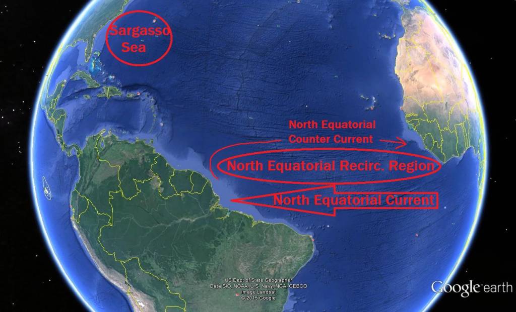
They were amazed at where it ended up. It wasn’t anywhere near the Caribbean, and it wasn’t anywhere near the Sargasso Sea. It wasn’t even anywhere near the Sargassum Loop System (which actually hadn’t been discovered yet). It was in a huge, elongated eddy that lies just above the equator and reaches all the way from South America to Africa. It’s called the North Equatorial Recirculation Region. While the huge Equatorial Current is taking everything west, this eddy forms above it, bounded on its north by a weak, usually seasonal current called the North Equatorial Counter Current. This explained why there had been landfalls not just here in the Caribbean, which has always gotten some sargassum, but also in places like Brazil, and even on the coast of Africa in places like Sierra Leone, where it had never been seen before and people didn’t know what in the heck they were looking at. And the thing about this eddy, this North Equatorial Recirculation Region, is that it’s swimming in nutrients. It’s west end is right at the mouth of the Amazon River. It also gets iron-rich dust blown over from Africa, and coastal upwelling off that coastline as well. According to their software models, the sargassum stayed there for a “considerable time,” and it just loved that place. It grew exponentially, moving in eddy-like motions and sucking up all that warmth and all those nutrients and creating masses and masses of itself—and then the counter-current broke down. The eddy vanished, the floodgates opened, and all that sargassum started across the Caribbean toward us.
The Sargassum Loop System
I’ve written before about eutrophication, when I did a piece on jellyfish. It’s a word you’ll be hearing more of, unfortunately, as we pummel this planet harder and harder, and sure enough, it figures in this story too. Looked at simply, eutrophication is when excess nutrients wash into a body of water and mess everything up. The first thing that happens is an algae bloom, and that could be anything from phytoplankton to sargassum, and then as that stuff dies, the decomposition process robs the water of all its oxygen, and you end up with what marine biologists call a dead zone. This happens in big ways and small ones—I know divers who can swim down our barrier reef and tell you resort by resort whose septic systems aren’t working. But rivers like the Mississippi and the Amazon empty entire continents of their nutrients, and that now includes fertilizers, pesticides, industrial waste and discharge from sewage treatment plants. You can see the dead zones on Google Earth now. Look for the little dead fish icons. They’re courtesy of William and Mary College and the World Resources Institute (and thank you, Google, for being willing to display them!) The second biggest dead zone in the world is in a plume running west from the mouth of the Mississippi, which is why the sargassum grows so riotously in the north-west Gulf of Mexico, and man, if you think we’ve got problems, you should see the sargassum in Texas. They get it on a classic Texan scale. The piles on the beaches (called wracks) can be ten feet high there, especially around Galveston. When it comes in, they call it the golden tide.
And sargassum isn’t the only seaweed going nuts from eutrophication. On the Brittany coast in France, they got a green tide of sea lettuce (Ulva armoricana) in 2009 that off-gassed so much hydrogen sulfide that it killed a horse and rendered its rider unconscious. In 2011 it returned and killed thirty-six wild boars. The sensational press coverage left everyone with the impression that the seaweed was toxic (it’s not, but hydrogen sulfide is nothing to trifle with). The cause was clear: factory agriculture. Nutrients come in (in animal feed) but they don’t go out (no one returns the manure to sender), so there’s a gargantuan net increase in the nutrients in the Brittany area, and they end up in the ocean. Measures to curtail factory farming caused layoffs, closures and protests. The tourist industry there is 5 million dollars per year. The agriculture industry is 11.6. They’re still fighting.
In China, on the shores of the notoriously eutrophic Yellow Sea, the largest green tide ever recorded hit the beaches of Qingdao three weeks before the Olympics and its sailing regatta. The Chinese rose to it in impressive fashion: In just three weeks they removed a million tons of Ulva prolifera from the beaches in an operation that involved 10,000 people and cost thirty million dollars. Then they put up a boom to keep the stuff out that was thirty kilometers long.
* * * *
-
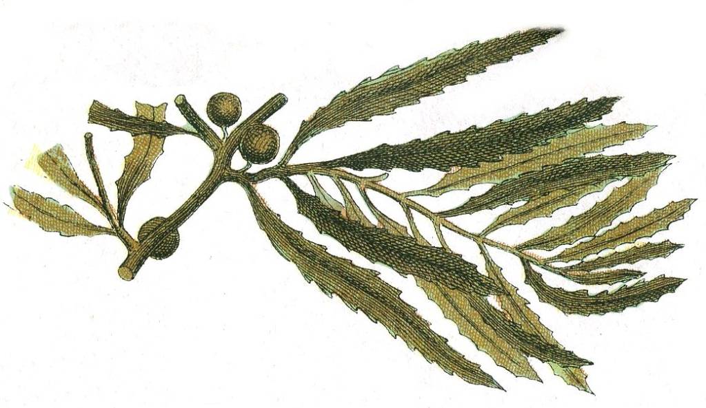
Sargassum Natans
So, the picture that’s shaping up in the mind of this amateur naturalist looks something like this: The sargassum spends most of a year, or even more than a year, hanging out somewhere it has never been before, which is in the North Equatorial Recirculation Region, and it circles and blooms and circles and blooms. Then at some point, the countercurrent bounding it on the north dissipates, the eddying stops, and the sargassum floods out, rejoins the Sargassum Loop System and buries our beaches. But there’s a huge question still unanswered, which, of course, is this: How in the hell did sargassum start getting into the North Equatorial Recirculation Region? Nobody knows. Johnson and his team say that the causes “have not yet been elucidated,” but they suspect a link with global warming.
A voice in my head is going, I should have known. Climate change, and eutrophication.Both.
And they could both in theory be fixed, because the good news and the bad news here is that they’re both anthropogenic. Anthropogenic is a scientific term meaning caused by humans. But I prefer how the great Jimmy Buffet would put it:
It’s our own damn fault.
Now you know.
I have read many comments and reasonings about how, where, and for how long we will have to deal with the sargasso attack that started last year July. I live on the Jade Bay beach for 13 years now and obviously have been enjoying life in paradise. With that came the daily observation of weather, wind, waves, sea rise level etc. What happened last year July?? Last year July the prevailing wind along the coast of Quintana Roo shifted from North-East to South East. Remember the time before July 2014. So little have been said, written or studied about this significant change in prevailing wind direction in the Carribean Sea and in particular along our coast. In the past, the days that the wind blew from the South East in a year, could be counted on two hands and only caused an increase of plastic debris and some sargasso coming to our shore. Watch what happens to the influx of sargasso when the wind shifts back to the North East for one or two days? It reduces significantly, it even stops after two days of wind from that corner. We have to ask the question; was the sargasso always at our doorstep but never reached our shores thanks to the prevailing wind direction? What happened? On the West coast of Mexico El Niño is very present and has influence on our weather condition, like temperature, atmospheric conditions that may favour or not the formation of depressions that may result in tropical storms or hurricanes. El Niño may also be the cause of the change in our prevailing wind direction, right? What’s going to happen from now on? It is predicted that El Niño will die in the period from next December till March. Will we get our prevailing wind direction back by then and that will put an end to our sargasso suffering? So many questions to answer yet but I believe that this will indeed be the case.